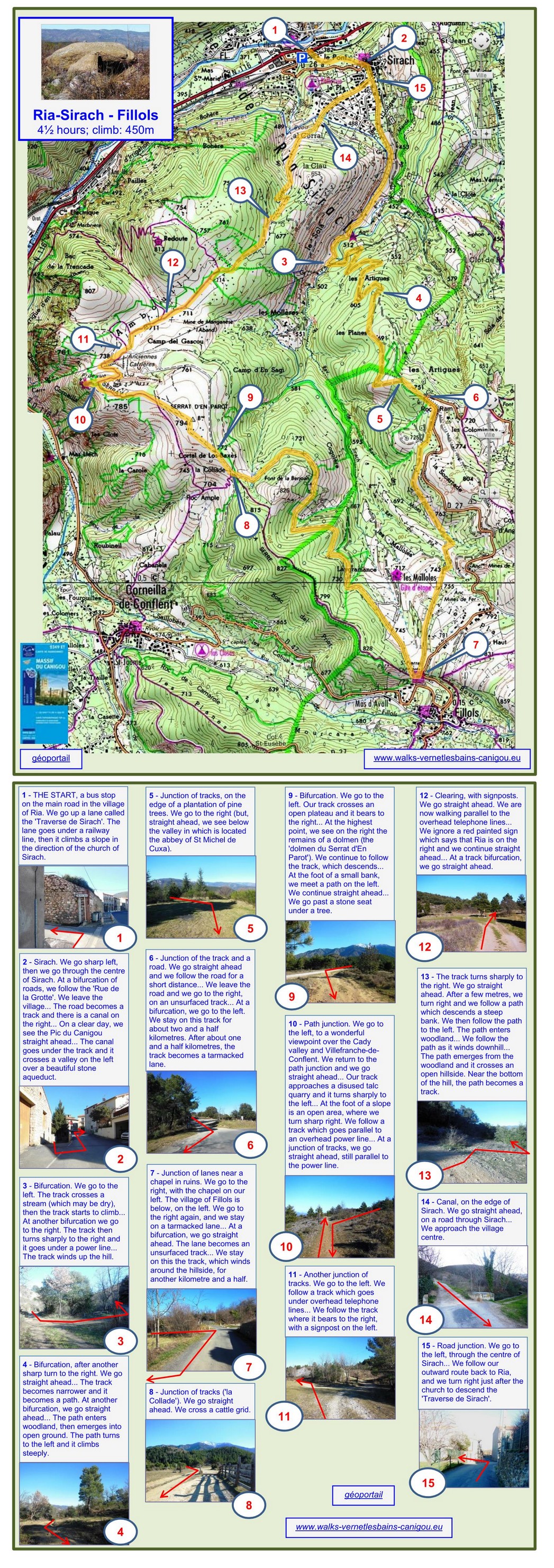
5 hours; climb: 450m
A pleasant circuit between Ria and Fillols, with fine views of Canigou and some interesting ancient monuments en route.
1 - THE START, a bus stop on the main road in the village of Ria. We go up a lane called the 'Traverse de Sirach'. The lane goes under a railway line, then it climbs a slope in the direction of the church of Sirach. At a fork, we ignore a track going to the right.
2 - Sirach. We go sharp left, then we go through the centre of Sirach. At a bifurcation of roads, we follow the 'Rue de la Grotte'. We leave the village... The road becomes a track and there is a canal on the right... On a clear day, we see the Pic du Canigou straight ahead... The canal goes under the track and it crosses a valley on the left over a beautiful stone aqueduct.
3 - Bifurcation. We go to the left. The track crosses a stream (which may be dry), then the track starts to climb... At another bifurcation we go to the right. The track then turns sharply to the right and it goes under a power line... The track winds up the hill.
4 - Bifurcation, after another sharp turn to the right. We go straight ahead... The track becomes narrower and it becomes a path... At another bifurcation, we go straight ahead... The path enters woodland, then emerges into open ground. The path turns to the left and it climbs steeply.
5 - Junction of tracks, on the edge of a plantation of pine trees. We go to the right (but, from a point a few metres on the left, we see below the valley in which is located the abbey of St Michel de Cuxa).
6 - Junction of the track and a road. We go straight ahead and we follow the road for a short distance... We leave the road and we go to the right, on an unsurfaced track... At a bifurcation, we go to the left. We stay on this track for about two and a half kilometres. After about one and a half kilometres, the track becomes a tarmacked lane.
7 - Junction of lanes near a chapel in ruins. We go to the right, with the chapel on our left. The village of Fillols is below, on the left. We go to the right again, and we stay on a tarmacked lane... At a bifurcation, we go straight ahead. The lane becomes an unsurfaced track... We stay on this the track, which winds around the hillside, for about another two kilometres.
8 - Junction of tracks ('la Collade'). We go straight ahead. We cross a cattle grid.
9 - Bifurcation. We go to the left. Our track crosses an open plateau and it bears to the right... At the highest point, we see on the right the remains of a dolmen (the 'dolmen du Serrat d'En Parot'). We continue to follow the track, which descends... At the foot of a small bank, we meet a path on the left. We continue straight ahead... We go past a stone seat under a tree.
10 - Path junction. We go to the left, to a wonderful viewpoint over the Cady valley and Villefranche-de-Conflent. We return to the path junction and we go straight ahead... Our track approaches a disused talc quarry and it turns sharply to the left... At the foot of a slope is an open area, where we turn sharp right. We follow a track which goes parallel to an overhead power line... At a junction of tracks, we keep to the track on the right, still parallel to the power line.
11 - Another junction of tracks. We go to the left. We follow a track which goes under overhead telephone lines... We follow the track where it bears to the right, with a signpost on the left.
12 - Clearing, with signposts. We go straight ahead. We are now walking parallel to the overhead telephone lines... We ignore a red painted sign which says that Ria is on the right and we continue straight ahead... At a track bifurcation, we go straight ahead.
13 - The track turns sharply to the right. We go straight ahead. After only a few metres, we turn right and we follow a path which descends a steep bank. We then follow the path to the left. The path enters woodland... We follow the path as it winds downhill... The path emerges from the woodland and it crosses an open hillside. Near the bottom of the hill, the path becomes a track.
14 - Canal, on the edge of Sirach. We go straight ahead, on a road through Sirach... We approach the village centre.
15 - Road junction. We go to the left, through the centre of Sirach... From here, we follow our outward route back to Ria. We turn right just after the church to descend the 'Traverse de Sirach'.
2025