3½ hours; climb: 400m
This circuit follows paths through chestnut, pine and oak forests. It connects Vernet-les-Bains and the village of Sahorre, in the Rotja Valley. It passes the remains of a once-flourishing iron-ore mining industry. The route follows in part a signposted trail called the "Sentier de Falguerosa".
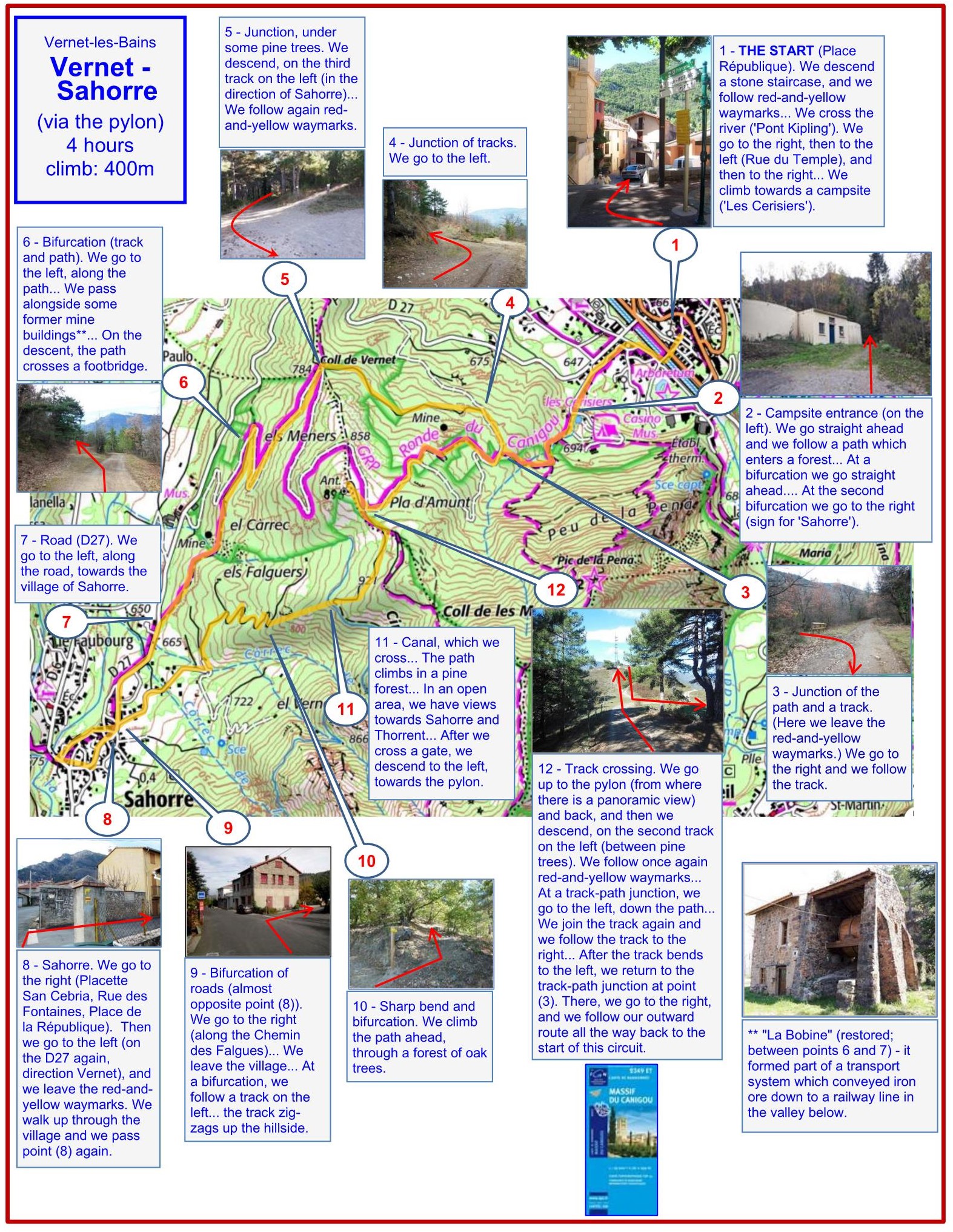
1 - THE START (Place République). We descend a stone staircase, and we follow red-and-yellow waymarks... We cross the river ('Pont Kipling'). We go to the right, then to the left (Rue du Temple), and then to the right... We climb towards a campsite ('Les Cerisiers').
2 - Campsite entrance (on the left). We go straight ahead and we follow a path which enters a forest... At a bifurcation we go straight ahead.... At the second bifurcation we go to the right (sign for 'Sahorre').
3 - Junction of the path and a track. (Here we leave the red-and-yellow waymarks.) We go to the right and we follow the track.
4 - Junction of tracks. We go to the left.
5 - Junction, under some pine trees. We descend, on the third track on the left (in the direction of Sahorre)... We follow again red-and-yellow waymarks.
6 - Bifurcation (track and path). We go to the left, along the path... We pass alongside some former mine buildings (including the restored 'Bobine', which formed part of a transport system which conveyed iron ore down to a railway line in the valley below)... On the descent, the path crosses a footbridge.
7 - Road (D27). We go to the left, along the road, towards the village of Sahorre.
8 - Sahorre. We go to the right (Placette San Cebria, Rue des Fontaines, Place de la République). Then we go to the left (on the D27 again, direction Vernet), and we leave the red-and-yellow waymarks. We walk up through the village and we pass point (8) again.
9 - Bifurcation of roads (almost opposite point (8)). We go to the right (along the Chemin des Falgues)... We leave the village... At a bifurcation, we follow a track on the left... the track zig-zags up the hillside.
10 - Sharp bend and bifurcation. We climb the path ahead, through a forest of oak trees.
11 - Canal, which we cross... The path climbs in a pine forest... In an open area, we have views towards Sahorre and Thorrent... After we cross a gate, we descend to the left, towards the pylon.
12 - Track crossing. We go up to the pylon (from where there is a panoramic view) and back, and then we descend, on the second track on the left (between pine trees). We follow once again red-and-yellow waymarks... At a track-path junction, we go to the left, down the path... We join the track again and we follow the track to the right... After the track bends to the left, we return to the track-path junction at point (3). There, we go to the right, and we follow our outward route all the way back to the start of this circuit.
2023